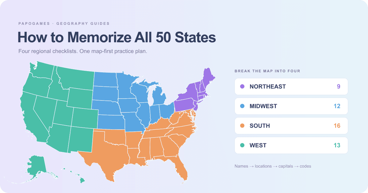
To memorize all 50 US states, start with four regional groups rather than one long alphabetical list. Learn where each group sits on the map, recall the names without looking, and return to the states you missed. Once the names are familiar, practise capitals and postal abbreviations as separate tasks. They test different answers, and switching between them too early can hide what you actually know.
This guide uses State Sprint, the free US states quiz. Its practice modes let you work on one region without a countdown; Name all 50 adds a five-minute challenge when you are ready. You can use the plan below at your own pace. It is a suggested practice routine, not a promise that everyone will learn the map in a fixed number of minutes.
1. Break the map into four regional checklists
The US Census Bureau groups states into the Northeast, Midwest, South and West. These are the regional groups used by State Sprint. The checklist below contains states only: Washington, D.C. is not one of the fifty, even though Census regional statistics also include the district.
| Region | States | Count |
|---|---|---|
| Northeast | Connecticut, Maine, Massachusetts, New Hampshire, New Jersey, New York, Pennsylvania, Rhode Island, Vermont | 9 |
| Midwest | Illinois, Indiana, Iowa, Kansas, Michigan, Minnesota, Missouri, Nebraska, North Dakota, Ohio, South Dakota, Wisconsin | 12 |
| South | Alabama, Arkansas, Delaware, Florida, Georgia, Kentucky, Louisiana, Maryland, Mississippi, North Carolina, Oklahoma, South Carolina, Tennessee, Texas, Virginia, West Virginia | 16 |
| West | Alaska, Arizona, California, Colorado, Hawaii, Idaho, Montana, Nevada, New Mexico, Oregon, Utah, Washington, Wyoming | 13 |
Pick one region and find every state in it before moving on. The Northeast is a useful starting group because it has nine states, but its small shapes need attention. If you are more comfortable with the West, start there instead. The aim is to create a group you can recall confidently, then connect it to the next group.
2. Give yourself the same route around the map
An alphabetical list helps you check completeness, but it does not tell you where a missing state belongs. Try a visual sweep instead: locate the Pacific coast, follow the northern part of the map, move to the Atlantic side, then fill in the South and the interior. The sweep is a memory aid; the quiz accepts names in any order and does not require neighboring states.
- Use California, Oregon and Washington as your Pacific coast anchors.
- Treat North Dakota and South Dakota as a pair. Do the same for North Carolina and South Carolina, then Virginia and West Virginia.
- Zoom your attention toward the small eastern states. Delaware, Rhode Island, Connecticut and Maryland are easy to overlook on a full-country view.
- Finish every sweep by checking Alaska and Hawaii. Their inset positions on this quiz map are for display, not a distance or size comparison.
After a round, write down the missing names before starting again. If you remembered thirty-eight states, practising those same thirty-eight immediately gives little information about the twelve missing ones. Open Practice missed states and build a short list of the gaps instead.
3. Keep state names, capitals and abbreviations separate
A correct state name is not the same answer as its capital or its two-letter postal code. State Sprint separates these tasks so you can practise one relationship at a time. In Name all 50, type full state names; a postal abbreviation does not replace the name. In the map quiz, identify the state shape. In capitals mode, answer with the city.
| State | Capital to practise | Common mix-up to avoid |
|---|---|---|
| New York | Albany | New York City |
| California | Sacramento | Los Angeles or San Francisco |
| Illinois | Springfield | Chicago |
| Alaska | Juneau | Anchorage |
| Washington | Olympia | Seattle or Washington, D.C. |
| Nevada | Carson City | Las Vegas |
| Kentucky | Frankfort | Louisville |
| Maryland | Annapolis | Baltimore |
For abbreviations, practise the easily confused sets together: AK is Alaska, AL is Alabama and AR is Arkansas; AZ is Arizona. Then separate the M states: ME, MD, MA, MI, MN, MS, MO and MT. The US Postal Service abbreviation list is the reference for these two-letter forms. In State Sprint, use the Abbreviations mode when you want those codes to be the answers.
4. Use a five-session practice loop
A session can be a short break rather than a long study block. Repeat a step when it still feels uncertain; the sequence matters more than the calendar.
- Session 1: choose one region in Practice. Look at the names, then try recalling them without help.
- Session 2: revisit that region in Map quiz and start a second region. Say the location as well as the name.
- Session 3: complete a national naming round, then practise only the states you missed. Do not treat a revealed answer as one you recalled yourself.
- Session 4: use Capitals or Abbreviations for a separate round. Return to the full names afterwards to check that the tasks stay distinct.
- Session 5: try Name all 50 under its five-minute clock, or the Daily dozen if you want a smaller timed set. Record what was missing, not just the final score.
What counts as a good result in State Sprint?
In Name all 50, each state recalled without a reveal is worth 100 points, so the maximum is 5,000. The Daily dozen uses twelve states and a maximum of 1,200. Both timed modes use five minutes of active play. Practice, Map quiz, Capitals and Abbreviations do not expire, so they are better places to slow down and correct a weak spot.
Showing an answer can help you learn, but it scores zero for that state. A perfect daily round means recalling all twelve yourself; the set follows the UTC date. Records and the daily streak stay in this browser, so changing devices or clearing site data will not carry them over automatically.
Choose the next geography skill to practise
Start with State Sprint when names, locations or capitals are the gap. Once the map is familiar, try Border Run and the US state borders strategy guide to practise which states actually touch. For a different kind of geography puzzle, the World Balance strategy guide explains how to compare countries by area and population.